Back to Explore Hikes
Bridalveil Fall Trail
Yosemite National Park, California, United States
Easy · 0.8 km · 20 min (visitor guidance: 20–30 min) · 24 m elevation
Out and back
Route not independently verified by AllHikes
Save HikeComing Soon
Distance
0.8 km
Difficulty
Easy
Estimated Time
20 min (visitor guidance: 20–30 min)
Elevation gain
24 m
Route Type
Out and back
Terrain / surface
Paved
About This Hike
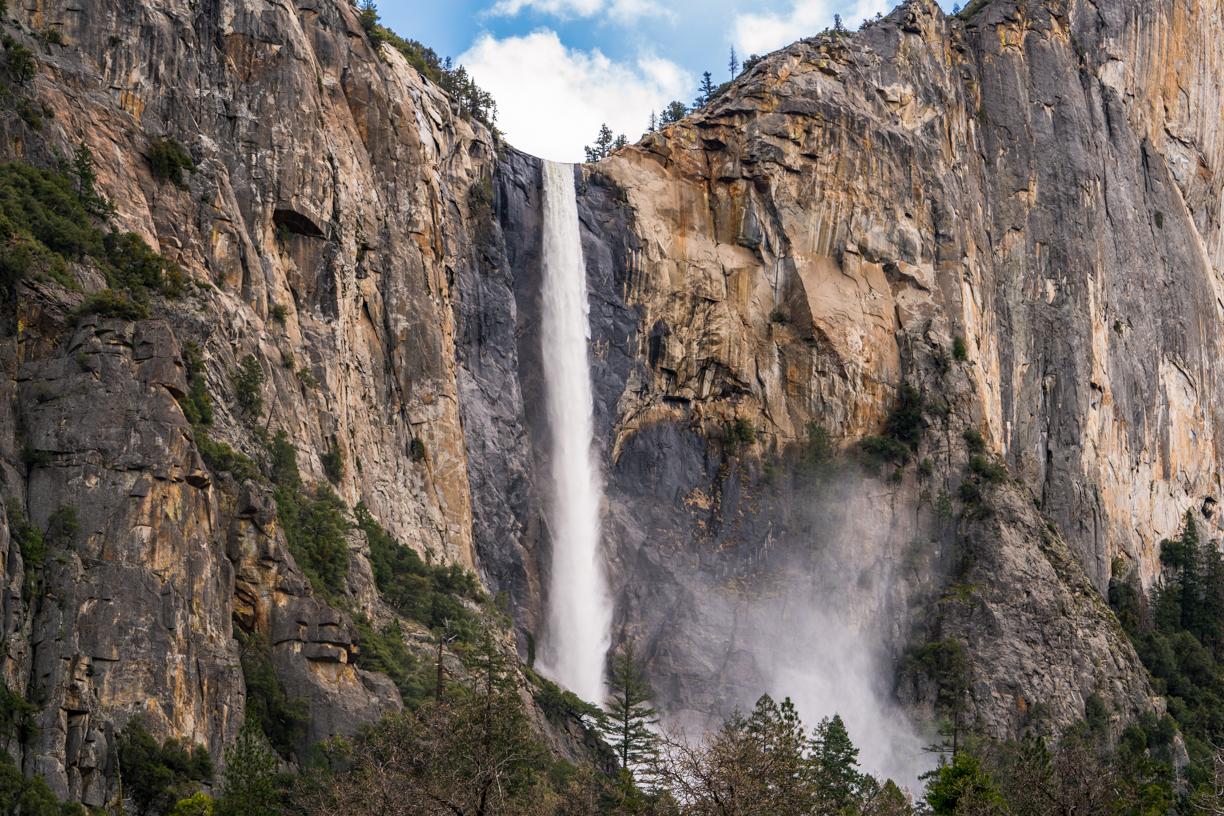
A short, paved out-and-back walk in Yosemite Valley to the base area of Bridalveil Fall, a 620 ft (189 m) waterfall. A wheelchair-accessible viewing platform sits partway along the trail; the final section to the closest viewing area is steeper and not wheelchair accessible.
Important — before you go
NPS lists the trail as open year-round, subject to conditions — check current Yosemite conditions before visiting. Expect slippery rocks, strong seasonal spray and possible winter ice.
Read all access and safety informationAdventure Highlights
- Water
- Views
- Photography
- Family
- Dog Friendly
- Discover one of Yosemite National Park’s iconic waterfalls on this short, scenic walk through Yosemite Valley. Bridalveil Fall plunges approximately 620 feet (189 metres) from the granite cliffs above, creating a spectacular sight, especially during spring and early summer.
- The paved trail climbs gently from the Bridalveil Fall parking area towards the waterfall. Enjoy views of Yosemite’s dramatic granite formations and the refreshing mist when water flow is strong.
- At approximately 0.5 miles (0.8 km) round trip, this easy walk is a wonderful option for families, casual walkers and visitors looking to experience Yosemite’s scenery without committing to a long hike.
- A wheelchair-accessible viewing platform is available partway along the trail, although the final section towards the closest viewing area is steeper and is not wheelchair accessible.
- Stay on the designated path and behind barriers. Rocks around the waterfall can be slippery, and winter conditions may bring ice. Check current park conditions before visiting.
Trail Gallery
What to Expect
Recorded terrain / surface: Paved. Recorded difficulty: Easy. An easy rating does not guarantee safety or accessibility.
Check the hike description and access guidance for recorded obstacles and limitations; consult the source for details not recorded here.
What to Bring
- Drinking water: Bring enough water for your visit
- drinking water is not available at the trailhead.
- Comfortable walking shoes: Wear shoes with good grip, especially when the trail is wet.
- Weather-appropriate clothing: Bring layers and a waterproof jacket when rain or waterfall spray is expected.
- Sun protection: Pack sunscreen, sunglasses and a hat for sunny conditions.
- Camera or smartphone: Capture the waterfall and Yosemite Valley’s spectacular granite scenery.
- Warm layers and traction: If visiting in winter, check conditions and prepare for icy or slippery sections.
- Snacks: Optional for this short walk, particularly if you plan to explore more of Yosemite Valley afterwards.
Check the weather and route conditions before setting out. Adapt your equipment to the route, season and your needs.
Before You Go — Essential Planning
NPS lists the trail as open year-round, subject to conditions — check current Yosemite conditions before visiting. Expect slippery rocks, strong seasonal spray and possible winter ice.
Last checked date unavailable — confirm current access and conditions locally before you go.
Check before departure
This page does not provide live opening status or weather. Confirm current access, permits, restrictions and conditions with the official authority. Missing information does not mean there are no restrictions.
Visit the recorded source (opens in a new tab)Where You'll Hike
- Country
- United States
- State / province / region
- California
- Park / protected or local area
- Yosemite National Park
- Trailhead / starting point
- Bridalveil Fall Parking Area, Yosemite Valley
Getting to the trailhead
Bridalveil Fall Parking Area, Yosemite Valley. Restrooms at the parking area. Parking can be busy during peak periods.
Sources & Last-Checked Information
www.nps.gov (opens in a new tab)Listing information is credited to this recorded source. A source link is not evidence of independent AllHikes route verification. A separate listing-information check date has not been recorded.
The safety-information check below is separate from route verification and is not a live conditions update.
Last checked date unavailable — confirm current access and conditions locally before you go.
Plan the whole adventure
Plan This Adventure
Build your complete adventure around this hike — including places to stay, food, transport, preparation and more.
Complete the Adventure
Your hike is only part of the journey. Discover places to stay, eat, travel and explore around your adventure.
Hike With a Club
Discover clubs exploring adventures like this one.
Your AllHikes Passport
Complete adventures and build your hiking history over time.
Community reports
Trail Conditions
Observations shared by hikers, reviewed before publication. They are not official safety information and never replace local guidance or emergency advice.
Missing or old reports don't mean a trail is safe.
Loading trail reports…
Community
Hiker Experiences
Real experiences from hikers who have completed this trail. These are personal accounts, not official AllHikes information.
Loading hiker experiences…
Hiked this trail?
Share your experience with the AllHikes community. Every experience is reviewed before it appears.